Object Record
Images
Metadata
Name |
Map |
Description |
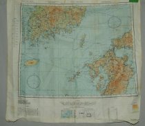
Map or Chart of Eastern Asia, made of cloth (mapbe silk). Reading Nagasaki on one side, Kagoshiiima on reverse. These maps/charts were used by American Air Force servicemen during WWII (World War II). If the maps got wet the maps were still usable. This map is in full color. Second edition, AMS 3 |
Image |
016\201105503.JPG |
Catalog Number |
2011.055.03 |
Search Terms |
Map Chart WWII Military Air Force China Sea World War War |
Size |
W-24.5 L-26 inches |
Subjects |
Sycamore |